leon
Level 4 Theurgist

Posts: 103
|
Post by leon on Jun 30, 2011 13:50:01 GMT -6
Is there a map of the original Greyhawk campaign setting available (the one which Gygax used to play, not the published one) or has somebody made an effort to recreate it?
|
|
|
|
Post by aldarron on Jun 30, 2011 17:32:28 GMT -6
No. Honestly, I doubt there was one. Would love to see it too. Originally they just used a map of North America as the general map and Outdoor Survival for the immediate region.
|
|
|
|
Post by snorri on Jun 30, 2011 18:45:30 GMT -6
This one could be a basis : 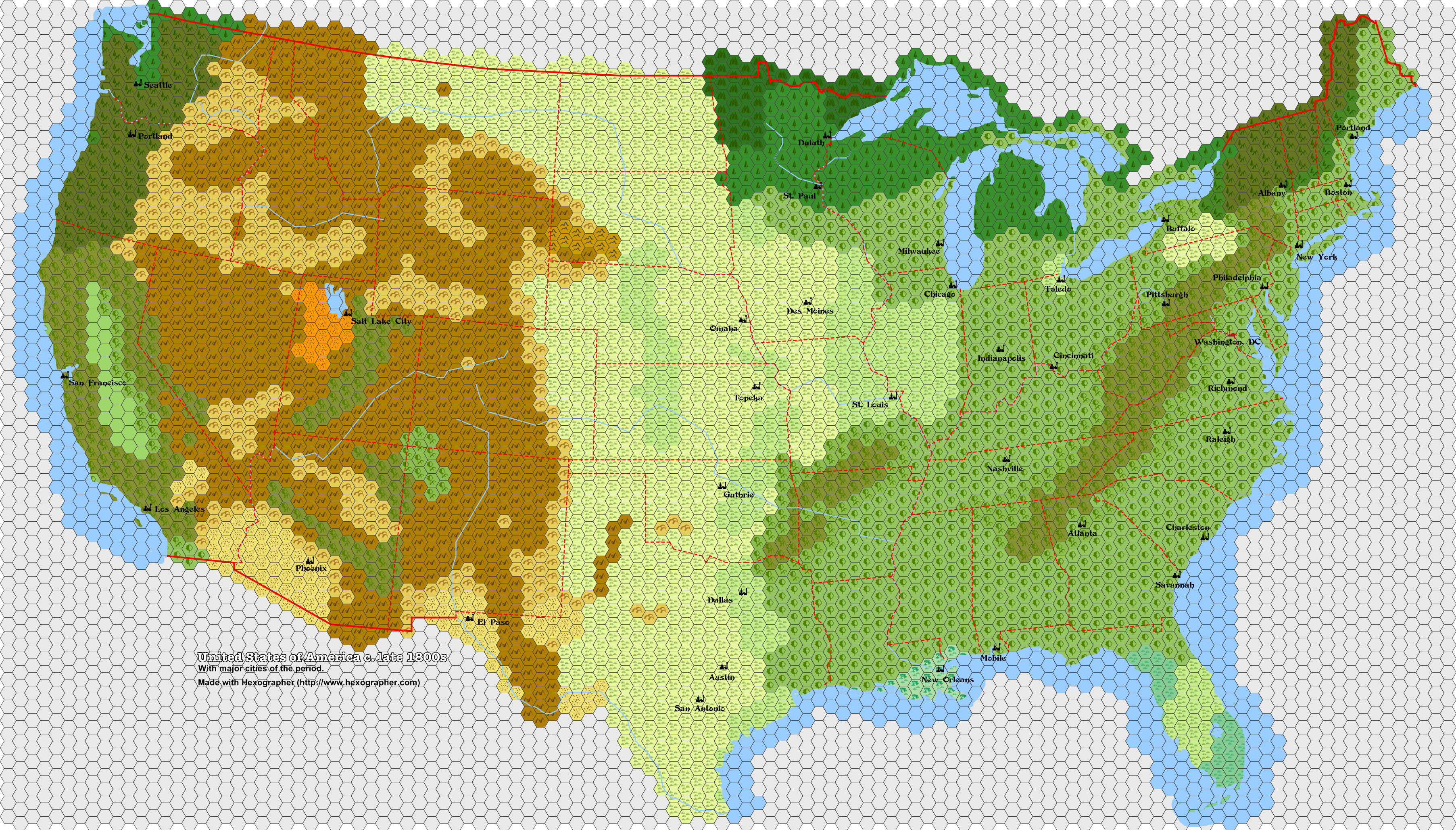  |
|
|
|
Post by Finarvyn on Jun 30, 2011 18:51:22 GMT -6
Snorri, that is so awesome! Have an EXALT for it! |
|
leon
Level 4 Theurgist
Posts: 103
|
Post by leon on Jun 30, 2011 19:45:05 GMT -6
That's great! This can be a good start. Now we need to somehow fit the various Greyhawk regions and cities to it. I wonder how this could be done without doing it completely arbitrarily.
|
|
|
|
Post by aldarron on Jun 30, 2011 19:54:07 GMT -6
Super-cool. Major cities, prolly should have Tampa and Denver and definetly Kansas City. Guthrie oklahoma? Never heard of it. <shrug>
|
|
Deleted
Deleted Member
Posts: 0
|
Post by Deleted on Dec 30, 2011 4:38:15 GMT -6
Snorri, I just found this thread and your map. I know that original Greyhawk was based on North America, and I agree that your map would be a great starting point. Now, if anyone could edit out actual place names and substitute Greyhawk campaign place names......
|
|
|
|
Post by Sean Michael Kelly on Dec 30, 2011 6:24:58 GMT -6
Looks like a fine map to use with Boot Hill!
|
|
|
|
Post by Finarvyn on Dec 30, 2011 8:24:01 GMT -6
Great idea, Sean! I've wanted a decent large-area map for Boot Hill and this should work great! |
|
|
|
Post by Sean Michael Kelly on Dec 30, 2011 11:17:59 GMT -6
|
|
|
|
Post by foxroe on Dec 30, 2011 21:37:15 GMT -6
Wasn't the map flipped upside down or something? I could swear I saw a hand-drawn original somewhere at some point... maybe I was dreaming about it.  BTW, sweet map Snorri! Definitely a must have for Boot Hill/ Western-RPG fans! Exalt! |
|
|
|
Post by perdustin on Jan 3, 2012 20:13:30 GMT -6
Guthrie was the de facto capital of the Oklahoma Territory and was quite modern for its time. Regardless, Kansas City, Denver, and Tampa should be represented on the map.
|
|
|
|
Post by Sean Michael Kelly on Jan 4, 2012 5:38:24 GMT -6
|
|
|
|
Post by aldarron on Jan 4, 2012 9:43:48 GMT -6
That is a much later version. " All members of this sub-group were interested in things medieval and I began publishing a magazine for them entitled Domesday Book. In an early issue, I drew up a map of the “Great Kingdom”. Members of the society could then establish their holdings on the map, and we planned to sponsor campaign-type gaming at some point. " Origins of the – Game- by Gary Gygax Dragon #7, pp. 7-8, June 1977 So the mystery map was published in an early Domesday newsletter. www.acaeum.com/library/domesday.htmlNone of the Acaeum contents lists mention a map, but letters 1 and 3 are not detailed and may no longer exist. I suspect that's why we have never seen the map. |
|
|
|
Post by grodog on Jan 4, 2012 21:31:30 GMT -6
Rob had a copy of the original campaign map, but it was lost quite some time ago, so the only likely chance that a copy survives is that Gary still had one in his possession (which of course means that Gail would have it).
All of the issues of the Domesday Book are validated to exist, so eventually we may see some sort of reprint of them, if we're lucky.
|
|
Deleted
Deleted Member
Posts: 0
|
Post by Deleted on Jan 14, 2012 17:09:05 GMT -6
Wow, great to see this map still out and in use and being updated after so many years. I originally drew this in back in the hey days of the TSR Online forums of AOL (I was TSRO Bocob, misspelled I know, but that was due to AOL's name length limits)... Heck I even got TSR's permission to post them for general use back then! The originals were in separate files, split by the folds in the original Darlene maps. The multiple file format was chosen due to memory restriction on my Win 3.1 PC way back when, and to keep the DL size lower since that was the day of 14.4 modems! This is why you see some anomalies like some place names being duplicated, like the Land of Black Ice, the Burneal Forest and the Yatil Mts. And if I remember correctly, I misspelled one of the city names off in the east. |
|
|
|
Post by Zenopus on Apr 24, 2012 9:31:06 GMT -6
Here's some info on the original Greyhawk Campaign map from Gygax's letter A&E#15 (Oct 76): "The game world is a parallel earth, but the continents are somewhat different. Most of our campaign activity takes place on what corresponds to North America, on the eastern half of the continent. The "Blackmoor" lands lie far up on the northeast coast. "Greyhawk" is in the central portion. There are a few other independently run campaigns located on this map. There are also some other dungeons related to the "Greyhawk" campaign located at some distance from the free city of Greyhawk. Players in our campaign may freely play in "Blackmoor", but to get there they must adventure cross country. With one or two other campaigns, we do not allow any cross-campaign play other than this, for these is too great a disparity of DMing. The territory within 500 or so miles of our main dungeon is mapped out at 5 miles to the hex. Territory within 50 miles of Greyhawk city is mapped more closely, and monster locations are indicated. The entire world is mapped out in rough form, with notes regarding typical encounters in given areas as well as particular special places, for hardy souls who wish to go forth to seek their fortunes." |
|
|
|
Post by DungeonDevil on Apr 24, 2012 12:12:46 GMT -6
Great map indeed! However I fail to see a border between MN and IA, unless my colour-blindness is playing tricks with me. BTW, what would the scale be for those hexes?
|
|
|
|
Post by havard on Apr 24, 2012 14:19:11 GMT -6
I suspect that Gygax' original map had the entire east coast under water, so that the border between Michigan and Indiana effectively became the new east coast. Blackmoor was located in Minnesota and Greyhawk was located in Michigan, probably near Lake Geneva. This is just speculation, but I think I am right  |
|
|
|
Post by James Maliszewski on Apr 24, 2012 16:54:45 GMT -6
If you look at the published map of the Flanaess (1980), even though it is not identical to Gary's original, North America-based map, the relationships are still much the same -- Greyhawk in the center near a large lake, Blackmoor northwest of that in the frozen north, the Great Kingdom to the east, etc. The Flanaess even looks a bit like North America, albeit warped.
|
|
|
|
Post by Zenopus on Aug 10, 2012 14:14:31 GMT -6
|
|
|
|
Post by blackbarn on Aug 14, 2012 11:36:00 GMT -6
Great post, thanks and exalt for that. |
|
|
|
Post by funkaoshi on Aug 14, 2012 12:05:08 GMT -6
|
|
|
|
Post by havard on Sept 15, 2012 10:08:37 GMT -6
I keep going back to this article Zenopus. Great work. Can't believe how long I was speculating on what that map may have looked like. Now we finally know -Havard |
|