Blackmoor town and dungeon alignment
Aug 27, 2010 15:19:50 GMT -6
howandwhy99 and scottenkainen like this
Post by aldarron on Aug 27, 2010 15:19:50 GMT -6
For reasons that are unknown to me, the town and castle of Blackmoor flipped nearly 180 degrees between the original town map published in the Domesday C&C newsletter, and the map drawn in Judges Guild First Fantasy Campaign. Basically what had been north became south. If I had to guess, maybe the dungeon maps were prepared by Judges Guild first and they may have mistaken a landscape layout view for normal and oriented North to what should have been east. I dunno.
The reorientation of the JG map does some really weird things to the town, such as making the south road exit from the north side of town, and making the Temple of Id, which is twice described in the text as northwest of town, lie to the south, but the real complication with the judges guild redraw is this: when level one is placed under the outline of the castle, the "Basement" hall and dungeon don't fit right, being at an odd right angle to the castle.
Further, the town orientation, relative to the expanded dungeon map on level 4, is completely off, no matter which way you turn it.
The whole problem is solved by marking west as north on the dungeon map and then using the original C&C map.
It should be noted that the Basement itself is a little confusing because, by all accounts and in the ZG version the basement is the large pillard hallway on level one. There is a second, different drawing marked “basement” in the FFC with the exact same outline but different interior, including what looks like a throne room. Apparently, judging from Bill Paley’s article in Alarums and Excursions about his 1975 Gen con experience, this can be explained as one of several stages of remodeling the same room.
I’ve played with some blow ups of the Castle from Dave’s original map, adjusting the approximate scale and superimposing the castle over level one. Using the JG orientation, with the town north of the castle, no matter how you line it up, it just doesn’t make much sense or fit the contours of the ground and the outline of the castle. It even puts the “side” entrance to the basement outside the castle walls!
However, if you go back to the original orientation of the town with the castle to the north and town to the south, turn the Dungeon maps so that “west” is north, everything lines up slick as snot. The large pillard hall of level one now matches the outline of the castle walls fairly well, especially if you place the main staircase in the round tower, as is logical.
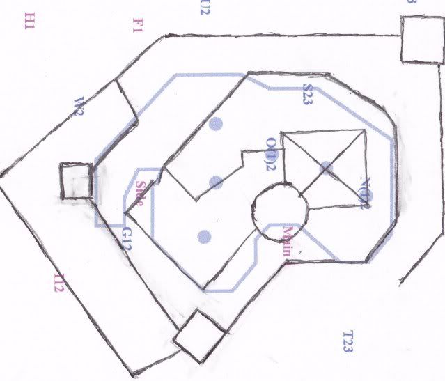
Below is my crude sketch of the castle overlaying the “basement” room of level one, drawn on to one of Tavis’s maps. The letters and numbers are his notations for the locations of stairways in the dungeon. The scale is not perfect but very close. The JG maps give the castle building as approximately 170 feet long and the Basement as 210, counting the extension arm, but interestingly enough, the main hall of the basement is 170 feet long, matching the castle. I scaled to that as best I could when blowing up the castle drawing but there’s some room for error so the castle may be very slightly larger or smaller than shown.

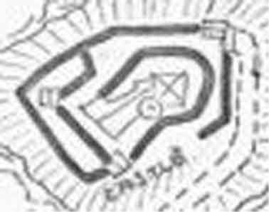
And for good measure, here is blow up of Arnesons' original drawing.

The reorientation of the JG map does some really weird things to the town, such as making the south road exit from the north side of town, and making the Temple of Id, which is twice described in the text as northwest of town, lie to the south, but the real complication with the judges guild redraw is this: when level one is placed under the outline of the castle, the "Basement" hall and dungeon don't fit right, being at an odd right angle to the castle.
Further, the town orientation, relative to the expanded dungeon map on level 4, is completely off, no matter which way you turn it.
The whole problem is solved by marking west as north on the dungeon map and then using the original C&C map.
It should be noted that the Basement itself is a little confusing because, by all accounts and in the ZG version the basement is the large pillard hallway on level one. There is a second, different drawing marked “basement” in the FFC with the exact same outline but different interior, including what looks like a throne room. Apparently, judging from Bill Paley’s article in Alarums and Excursions about his 1975 Gen con experience, this can be explained as one of several stages of remodeling the same room.
I’ve played with some blow ups of the Castle from Dave’s original map, adjusting the approximate scale and superimposing the castle over level one. Using the JG orientation, with the town north of the castle, no matter how you line it up, it just doesn’t make much sense or fit the contours of the ground and the outline of the castle. It even puts the “side” entrance to the basement outside the castle walls!
However, if you go back to the original orientation of the town with the castle to the north and town to the south, turn the Dungeon maps so that “west” is north, everything lines up slick as snot. The large pillard hall of level one now matches the outline of the castle walls fairly well, especially if you place the main staircase in the round tower, as is logical.
Below is my crude sketch of the castle overlaying the “basement” room of level one, drawn on to one of Tavis’s maps. The letters and numbers are his notations for the locations of stairways in the dungeon. The scale is not perfect but very close. The JG maps give the castle building as approximately 170 feet long and the Basement as 210, counting the extension arm, but interestingly enough, the main hall of the basement is 170 feet long, matching the castle. I scaled to that as best I could when blowing up the castle drawing but there’s some room for error so the castle may be very slightly larger or smaller than shown.

And for good measure, here is blow up of Arnesons' original drawing.


