|
|
Post by kent on Jul 4, 2013 14:41:41 GMT -6
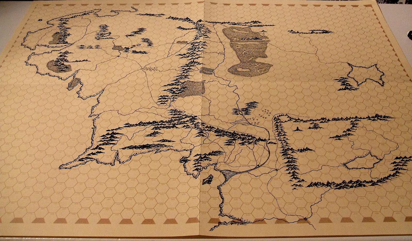
 [The forum software has reduced the image size. The image is larger on my blog] I haven't decided whether to include the placenames or not. What do you think, it looks neat without them and they are familiar at this stage? Next up I want to do the same with this map of Beleriand, including placenames this time. The idea is to have the maps for reading rather than gaming and yet having the maps will put thoughts in my head.  |
|
|
|
Post by Finarvyn on Jul 4, 2013 15:31:27 GMT -6
Looks pretty sweet, Kent. Count me as envious of this map.  Random thoughts and comments: 1. Any guess as to the hex-size in this format? 2. I like the notion of having some place-names, but maybe not too many. Or, at least some sort of marking the denotes citadels and cities and the like. (Helm's Deep, Minas Tirith, Rivendell, etc.) 3. If you decide to include place-names, you might go the Judges Guild route and have a player's map and a DM's map. The one you have posted above is a great player's map, as it has general geography but no secret information. 4. How the heck did you print this? I have a couple of blank JG map sheets from the 1970's, but my printer is nowhere large enough to print this thing. 5. My Middle-earth go-to map has long been the one from the SPI wargame War of the Ring. My copy is laminated so I can use it without getting it damaged. In some ways I like yours better. While the WotR map is pretty and colored, yours screams "old school" much better. More if I think of it. Great post! |
|
|
|
Post by kent on Jul 4, 2013 15:57:08 GMT -6
Looks pretty sweet, Kent. Count me as envious of this map.  Random thoughts and comments: 1. Any guess as to the hex-size in this format? 2. I like the notion of having some place-names, but maybe not too many. Or, at least some sort of marking the denotes citadels and cities and the like. (Helm's Deep, Minas Tirith, Rivendell, etc.) 3. If you decide to include place-names, you might go the Judges Guild route and have a player's map and a DM's map. The one you have posted above is a great player's map, as it has general geography but no secret information. 4. How the heck did you print this? I have a couple of blank JG map sheets from the 1970's, but my printer is nowhere large enough to print this thing. 5. My Middle-earth go-to map has long been the one from the SPI wargame War of the Ring. My copy is laminated so I can use it without getting it damaged. In some ways I like yours better. While the WotR map is pretty and colored, yours screams "old school" much better. More if I think of it. Great post! 1. Yes, edge to edge a hex is 40 miles. 2. That is a possibility. A map indicating to me where Rivendell is though strikes me as a not very useful addition unless seeing the word 'Rivendell' is an aesthetic improvement and this is what I need to consider. Tolkien's placenames are themselves evocative words. If I do add names they will be in red. 3. Heh, I won't be doing two similar maps. 4. Ah I see. No the map is hand drawn with an italic fountain pen and a 0.1mm pen. I thickened the mountains slightly here and there compared to Chris Tolkien's map and presented water by indicating the shoreline rather than with interior waves. 5. Ive heard good things about that wargame but I think it's pricey. |
|
|
|
Post by Otto Harkaman on Jul 4, 2013 16:16:39 GMT -6
I love it! Looks great without names! Gives a sense of wonder and makes you want to explore  Rivendell shouldn't be known, its a hidden secret haven  |
|
|
|
Post by geoffrey on Jul 4, 2013 18:54:59 GMT -6
Kent, your cartographic skills are impressive. It's interesting to me that the Wilderlands maps are more evocative than the Middle-earth map. Bob Bledsaw and Bill Owen's maps are even better than Tolkien's.
|
|
|
|
Post by Finarvyn on Jul 4, 2013 20:58:57 GMT -6
How the heck did you print this? I have a couple of blank JG map sheets from the 1970's, but my printer is nowhere large enough to print this thing. 1No the map is hand drawn with an italic fountain pen and a 0.1mm pen. I thickened the mountains slightly here and there compared to Chris Tolkien's map and presented water by indicating the shoreline rather than with interior waves. Hand drawn! Holy cow! Now I'm even more impressed, and I can certainly see why you wouldn't want to do two of those. Working out the proportions so that it fit perfectly ... that so so darned cool!  |
|
|
|
Post by Otto Harkaman on Jul 4, 2013 21:55:48 GMT -6
It is incredible that you drew it, I was thinking also that you had printed it out on the judges guild hex sheet. If I may suggest you should get it photographed or scanned professionally for safe keeping. I am sure there must be a architectual and blue printing company near you.
|
|
|
|
Post by Falconer on Jul 4, 2013 22:02:05 GMT -6
Why does Mirkwood say “RHOVAN”?
|
|
|
|
Post by kent on Jul 5, 2013 7:42:00 GMT -6
I love it! Looks great without names! Gives a sense of wonder and makes you want to explore  Rivendell shouldn't be known, its a hidden secret haven  And also, if I was going to use it for a campaign, it might be look better with an invented terrain out eastwards on a second sheet without my placenames too. Kent, your cartographic skills are impressive. It's interesting to me that the Wilderlands maps are more evocative than the Middle-earth map. Bob Bledsaw and Bill Owen's maps are even better than Tolkien's. Bledsaw's and Tolkien's maps are quite different in purpose even though they look similar and apart from the factor of eight difference in scale. Bledsaw was mapping a terrain, and he was mapping it indiscriminately. There were no favoured locations or journey lines because there was no associated story. Tolkien was not concerned with terrain, which is only apparent on the maps where the story required it. His maps primarily indicate boundaries with impenetrable mountain ranges and rivers. His maps ask the reader, 'How do you think you could travel from here to here beyond these mountains.' Bledsaw's maps lack this majesty. Why does Mirkwood say “RHOVAN”? What you see is space for lettering if I so require it later. If I don't need it I will fill the spaces in. |
|
|
|
Post by thorswulf on Jul 5, 2013 13:57:28 GMT -6
Wow, I'm impressed that you were able to reproduce it so well! Makes me want to draw my own on what few large hex sheets I still own.
|
|
Aos
Level 1 Medium

Posts: 10
|
Post by Aos on Jul 6, 2013 11:46:06 GMT -6
Excellent map, Kent, I love the Africa one as well. I need to track down some of those JG hex sheets. I'd like to do something at this size. I especially like the way you did the shoreline. I'll be incorporating that technique into my own maps.
|
|
|
|
Post by kent on Jul 6, 2013 14:38:14 GMT -6
Thanks for the feedback.
The slow process of inking a fresh map gave me an opportunity to appreciate just what a good job Christopher Tolkien did, and of course C.T. deserves the credit if this map is pleasing to look at. It was the first fantasy map I studied, aged eleven, and I think it remains one of the very best Ive seen for style and structure, something which is hard to appreciate because of the remarkable familiarity we have with it.
Im really looking forward to working on Beleriand for the very reason it less familiar. I will be aiming to make it a twin of the above.
Does anyone have a reference to Christopher Tolkien discussing where he derived the style for his map?
|
|
|
|
Post by Otto Harkaman on Jul 6, 2013 16:53:37 GMT -6
His father? Who's drawings seem heavily influenced by early maps? I want to say medieval but I think they are more from the 15th century. His hills or mountains sometimes remind me of medieval maps of Jerusalem. I am just guessing.  |
|
|
|
Post by kent on Mar 11, 2014 19:04:29 GMT -6
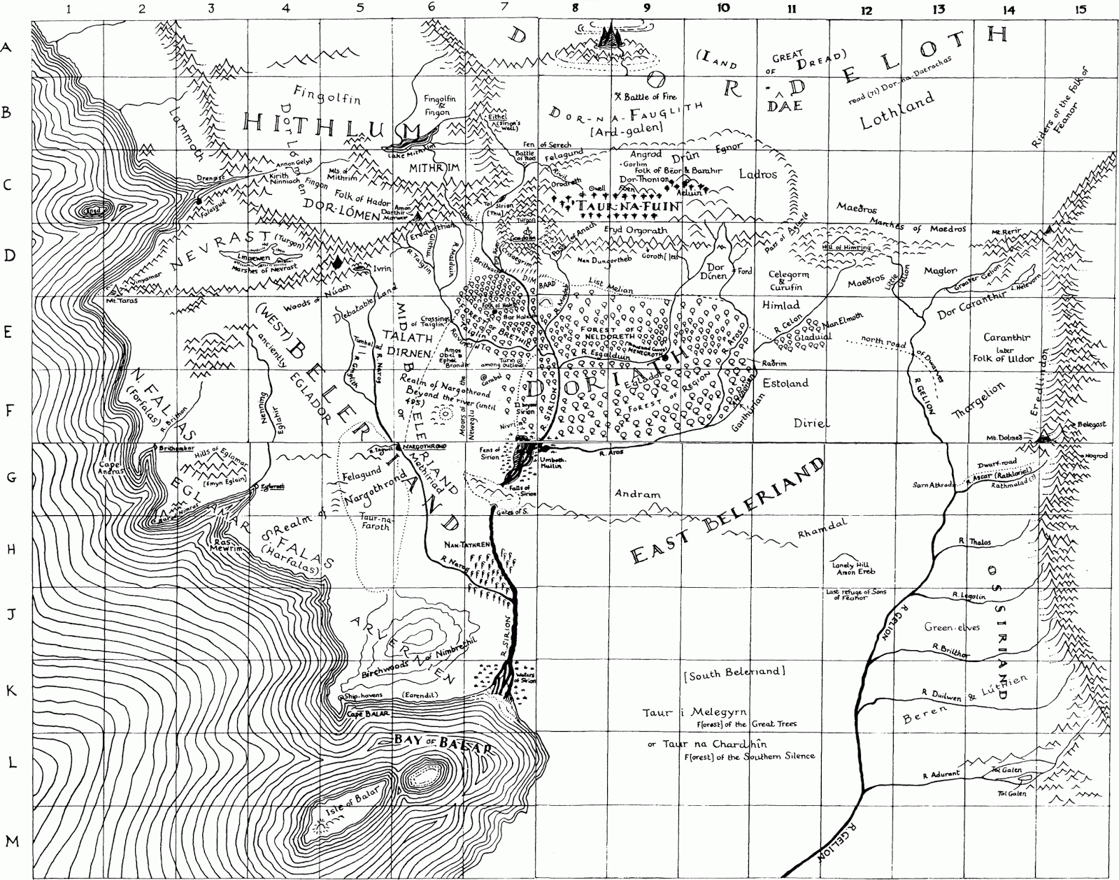
Does anyone recognise the B&W map of Beleriand above and where it comes from? I grabbed it from an image search assuming it was from one of the HoME volumes.
Also, using Ered Luin as a reference Ive always considered the standard Beleriand map to be about .6 the size of the LotR Middle-earth map - yes?
|
|
|
|
Post by geoffrey on Mar 11, 2014 20:16:50 GMT -6
Does anyone recognise the B&W map of Beleriand above and where it comes from? I grabbed it from an image search assuming it was from one of the HoME volumes. I seem to remember that map printed on the inside covers of my old trade paperback publications of either Unfinished Tales or The Silmarillion (purchased in the 1980s). The western half was printed in the front, and the eastern half was printed in the back. I think. My memory could be playing me tricks. |
|
|
|
Post by kent on Mar 11, 2014 20:32:24 GMT -6
Does anyone recognise the B&W map of Beleriand above and where it comes from? I grabbed it from an image search assuming it was from one of the HoME volumes. I seem to remember that map printed on the inside covers of my old trade paperback publications of either Unfinished Tales or The Silmarillion (purchased in the 1980s). The western half was printed in the front, and the eastern half was printed in the back. I think. My memory could be playing me tricks. OK. My own paperbacks which I have discarded had the standard maps. Chris Tolkien says that his father always used some old map version of Beleriand which is printed in BoLT II and 'feels' closer to the B&W map above. What I like about it is that it is layered with Elf & Orcs are here information lacking in the standard map. It also has what appears to be Thangorodrim in the north which is interesting although I have decided not to include that on my JG version - I have the impression Tolkien pushed it much further north in his own mind with time. |
|
|
|
Post by geoffrey on Mar 11, 2014 21:29:09 GMT -6
Here is the cover of my old trade paperback copy of Unfinished Tales:  I'm having trouble finding a picture of my old trade paperback copy of The Silmarillion. |
|
|
|
Post by kent on Mar 12, 2014 15:10:09 GMT -6
Geoffrey, are you confirming that the B&W map comes from that paperback edition or do you not have the book to hand? The map in HoME IV looks like an even rougher version of the above tailored for the Turin story. Perhaps the B&W version was made from it as a general Silmarillion map.
|
|
|
|
Post by geoffrey on Mar 12, 2014 16:24:39 GMT -6
Geoffrey, are you confirming that the B&W map comes from that paperback edition or do you not have the book to hand? The map in HoME IV looks like an even rougher version of the above tailored for the Turin story. Perhaps the B&W version was made from it as a general Silmarillion map. I am afraid that I do not have the book to hand. |
|
|
|
Post by kent on Mar 12, 2014 18:42:18 GMT -6
|
|
|
|
Post by Falconer on Mar 12, 2014 20:39:46 GMT -6
It is the same map from HoMe V, but he added more stuff to it for HoMe XI, and that’s the version posted above. I know because I created that GIF.
|
|
|
|
Post by geoffrey on Mar 12, 2014 21:19:00 GMT -6
My memory could be playing me tricks. Yep!  |
|
|
|
Post by kent on Mar 12, 2014 21:32:29 GMT -6
My memory could be playing me tricks. Yep!  That's OK the important question was that of legitimacy. It is the same map from HoMe V, but he added more stuff to it for HoMe XI, and that’s the version posted above. I know because I created that GIF. Does Chris T. say anything interesting about differences between it and the standard Beleriand map? For example why was Angband/Thangorodrim removed? |
|
|
|
Post by Falconer on Mar 13, 2014 9:54:50 GMT -6
I dunno, that Thangorodrim doodle is pretty cool, and there’s no reason it should be off the map when it’s literally RIGHT off the map. I’ll go look up if he says anything, tonight.
I think the general trend of leaving stuff off is just to make it as simple as possible to follow the story. Look at the ultra-simplified map in CoH, for example. I don’t think he really expects people to geek out about maps.
|
|
|
|
Post by grodog on Mar 13, 2014 23:37:50 GMT -6
Here is an interesting image from the article getting to grips with how Beleriand 'fits' with Eriador. Beleriand is small compared to the LotR map which is how I have imagined it reading first age material. Hmmm. That's interesting, I'd always assumed that the Beleriand map was comparable in scale to the LOTR map. Thanks for the pointer to the article, I'll check it out. |
|
|
|
Post by kent on Mar 15, 2014 14:30:20 GMT -6
I have inked the whole map but having inserted placenames for one quarter of the map my fountain pen nib became damaged. As it is a Lamy it is very cheap to get a new nib, $5. Anyway I hope you can see the process is relatively easy to achieve a familiar map on a richly textured sheet and frankly it is tempting to game in First Age Middle-earth when you have such an excellent resource as Robert Foster's extraordinary The Complete Guide To Middle-earth as a companion to the map. I did take license with the northern coastline having the fjords of Norway and Iceland in mind. While both maps are aesthetically fine thanks to the Tolkiens' design and functionally very useful for me they have both been practice runs for the more creative challenge of creating plausibly faithful maps of E.R. Eddison's Mercury and W.H. Hodgson's Night Land.  This picture just shows the relative sizes of Beleriand and Eriador.  |
|
|
|
Post by Falconer on Mar 15, 2014 21:16:40 GMT -6
I like the Beleriand map, Kent. The scale fits the JG hexes better than on the 3rd Age map, IMO.
|
|
|
|
Post by kent on Mar 16, 2014 7:14:03 GMT -6
I think the map itself is more compact and epic, almost any place looked up has some fascinating detail. The 3rd age map is spare in comparison presumably because it presents only two stories rather than the many of Beleriand. Beleriand feels much more lived in by Tolkien.
The scale of the hexes is immaterial to me because I never consider maps to be used for the clumsy sort of 'hex crawling' that produces maps with one symbol per hex. The hexes are simply a handy way of calculating distances and areas, and a neat way of indicating reference locations if Im making notes.
|
|
|
|
Post by kent on Mar 23, 2014 14:08:52 GMT -6
To what extent do you think the Third Age Middle-earth (TAME) map familiar from Lord of the Rings could be used in a First Age Middle-earth campaign?
Ered Luin, the mountain range in the utter north west of the TAME map is that in the utter east of Beleriand. It would be an interesting excercise to make minimal alterations to the TAME map so that those lands could be included in a First Age campaign. How would you alter the TAME map?
|
|
|
|
Post by Falconer on Mar 23, 2014 14:46:41 GMT -6
There should be one massive forest stretching from the Old Forest to Fangorn.
I would expect a Dwarf-road (the “East Road”) to run from Belegost and Nogrod to Khazad-dûm and thence to the Iron Hills.
The Vales of Anduin are where I would expect to find the most civilization. There the Northmen were said to have a symbiotic relationship with the Dwarves of Khazad-dûm, and there also dwelt the Nandor (the later Silvan Elves of Mirkwood and Lórien).
The Proto-Beornings would have dwelt in the Misty Mountains, up near the High Pass. Perhaps they were even larger then.
I would use Sindarin names whenever possible, to give it a First Age feel. Hithaeglir instead of Misty Mountains, for example.
I had the idea that Mordor was Ungoliant’s realm in the First Age.
|
|